History of San Quintín Valley
In the 1880´s some lands were British owned, the company “Colonization Company” acquired much of the area in order to create an empire of wheat, which had progress.
A mill and a wharf were built for wheat transportation, this required, the construction of a rail way in order to unite a road that lead from the south to the pacific. However, a drought devastated the empire and by 1900 the colonists had abandoned San Quintín.
The town of San Quintín is it self more than a variety of shops, restaurants, hotels and other businesses along the Highway. There are much needed services such as 24 hour long distance telephone booths, 24 hour open clinics and hospitals, travel agencies, internet cafes, banks Banamex, Bancomer and HSBC banks.
Visitors passing through the road of San Quintín will find at a simple their business needs. But beyond that, this place offers attractions for those who like fishing and hunting because it has a varied number of species and fauna. Or just for those who enjoy observing and long walks by the beach.
Sierra San Pedro Mártir National Park, was establish in 1947, covering an area of 170.000 acres; Here is located the highest mountains in the Baja California Peninsula.
Like all mountains of northern Baja California, with their points facing west, and its highest peaks pushing along the precipitous eastern slope. The highest peak of the peninsula is the Picacho del Diablo, also known as Cerro de la Encantada and La Providencia. Favorite place for those who enjoy hiking and carrying a backpack in the shoulder, where they can choose from a network of trails and camp sites.
Also for those who enjoy mountain biking this is an alternative to enjoy since the ground conditions are ideal and considered among the best. Given to the conditions of air, the clarity and remote pollution, in this point of the park, the Mexican government declared it as the National Astronomical Observatory in the year of 1967; which can be accessed at 20 kms. Passing the entrance to it, the Dome Mountain is located at an elevation of 2,830 meters. There you will find a locked gate, which means that visitors must leave their car parked at the point, and walk 2 km more to reach a dome where several telescopes are located in order to be used, in which among which Mexico's longest reflector which measures 2.11 meters.
Location and Topography
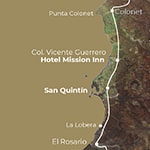
Located in the municipality of Ensenada in Baja California Mexcio, Latitude 30 '33' 37 N, Longitude 115 33 `56` O, Altitude 28 meters above sea level, phone prefix (616) Zip Code 22940, Official Time Zone Pacific Time. Sister Cities Colonia Vicente Guerrero CP 22920, CP 22910 Camalú Lázaro Cárdenas CP 22931, Colonet CP 22909, CP 22914 San Telmo.
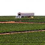
Now in a day is more a plain than a valley, in which among is arrow of seven, extinct volcanic cones to the west and six in the peninsula, one in the San Martin Island, right next to the edge of the beach and the Sierra San Miguel in the east. Two small rivers, San Miguel and Santa Maria, crossing the plane from east to west, feeding an irrigation system that turns the valley into a major center for growing vegetables.
Many individuals from Oaxaca and Chiapas, work on these plantations and live on the outskirts of San Quintín.
For visitors, one of the main attractions is the coastal and complex environment. Since it has interconnected bays which are: Bay of San Quintín, Bahia Falsa and Bahia Santa Maria.
The inner bay, surrounded by tidal flats and marshes, are known as San Quintín Bay and San Quintín Port. The outer bay, looking toward the Pacific, is called Santa Maria Bay, south to the tip of Cabo San Quintín, better known as Bahia San Quintín.

Weather
The temperature in the valley of San Quintín is 26° C in July and August during the day and 4.5° C at night. During the months of December to March the temperature is 4.5° C and can drop to -12° C, the coldest nights are in the spring and autumn, during the day in these months the temperature can be maintained between 15 and 21° C. Snow is common above 2,000 meters during the winter at the Picacho del Diablo. And the rains fall and occasionally are ending the summer, during spring and early summer and autumn is usually dry.

Fauna and Flora
Find plants such as stands of pine, oak, juniper and numerous species of flora and desert chaparral and sage, verbena, yucca and palm. On the other hand we also find piñon, Jeffrey pine, white fir, incense cedar, sugar pine and at least three species not found elsewhere in Baja California as aspen, lodgepole pine, cypress of San Pedro Martir. Fauna in no particular order is the donkey deer, mountain lion, wild cat, coyotes, and so rare Borregón. Pets and cattle and sheep.
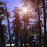
The National Park comprises the wooded portion located within the mountainous Sierra de San Pedro Martir. This is one of the few tracts of mountain forest located in the Peninsula of Baja California.
It has a variety of conifer species and serves as an important refuge for the wildlife on the peninsula, whose species, some of endemic nature, can be seen the bighorn sheep.
It’s located in the central part of the state of Baja California, whose region corresponds to the municipality of Ensenada.
The area was explored for the first time around the year of 1701 by the expeditions of Eusebio Francisco Kino, it was the Dominican order who established the first mission in place.
Within the national park boundaries, in the mountainous elevation known as Cerro de la Cupula, the National Astronomical Observatory of Mexico was established in 1971, which is the second most important in Latin America.
Very close to the Observatory is the Picacho del Diablo, which is the highest point of the entire peninsula reaching 3,095 meters above sea level, which is also within the national park.
To obtain more information about the National Park and Observatory schedules, please contact the following telephone number 078.
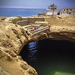
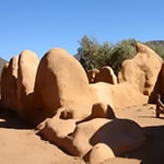
Approximately 40 miles south of San Quintín is a unique natural attraction known as La Lobera, which is a Sea Lion sanctuary. In this site, the rocky shore has faced over millions of years strong tides and high waves of the coast of Baja California, forming great cavities between the stone where the sea penetrates. This phenomenon has given rise to an amazing crater located some 150 meters inland, which has served as a refuge for seals and sea lions. The crater has around 30 meters in diameter at the top and 60 meters on the inside, with around 15 meters of deepness.
From the top you can see these beautiful creatures. Nearby, The Farm (La Granja) implements larval systems for the cultivation of Abalone and other marine species such as lobster. You can ask for permission to the residents, who are very nice people, to stay within the area.
The site of Santo Domingo de la Frontera was explored during the year of 1775 by the Dominicans Manuel Garcia and Miguel Hidalgo, the same who established the mission on August 30th of this year. Originally established 30 km from the Bay of San Quintín. Between 1775 and 1797, the religious Manuel García, Miguel Hidalgo, José Avian Miguel Abad and Jaime Covina, served as residents ministers. It was a prosperous mission in which olives, grapes, figs, pear, prickly pear, wheat, corn and peas were cultivated , aided by ditches to carry water; further progress was made in cattle, having a production of cows, sheep, goats , pigs, horses, mules and donkeys. Without a known reason in 1839 it was abandoned, being the second mission built on the Camino Real.
Gallery